Methodology: Resilience-adjusted Risk with Triple-layer Adaptation Offset
Overview
Physical hazard models show where climate risks intensify but do not capture how local adaptation changes mitigate damage on the ground. AlphaGeo’s Climate Risk and Resilience Index (CRRI) closes that gap with a novel "resilience-adjusted risk" framework that integrates high-resolution geospatial data on adaptation into climate risk models, resulting in a Resilience-Adjusted Risk assessment for any location worldwide.
This framework produces two complementary outputs:
- Physical Risk Impact — the unmitigated baseline based on hazard intensity alone
- Resilience-Adjusted Risk Impact — the likely real-world impact after resilience factors are applied
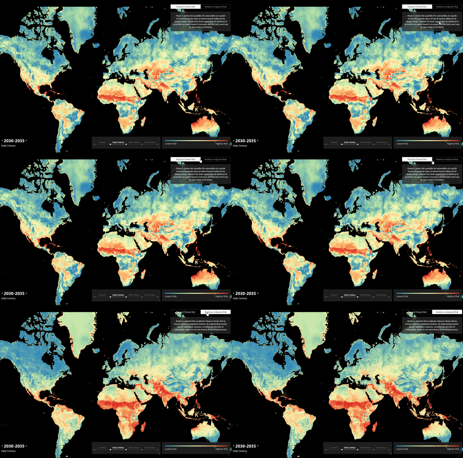
Toggling between Physical Risk and resilience-adjusted risk reveals how local resilience changes likely impact at the same location.
Why resilience-adjusted risk matters
Traditional climate risk assessments focus on physical hazards such as heat stress, drought, flooding, and wildfire. That baseline is essential, but incomplete.
Two locations can face similar hazard intensity and still experience different outcomes. Flood barriers, drainage, building quality, emergency response capacity, and broader societal resilience all shape likely damage. CRRI captures those differences directly.
How CRRI calculates impact
CRRI follows a four-step framework:
- Measure hazard intensity for each hazard category at a given location, time horizon, and scenario.
- Convert intensity into damage using a hazard-specific damage function.
- Apply three layers of hazard-specific adaptation offsets, based on:
- Local adaptation capacity: Local or community-level infrastructural adaptations (e.g., flood defenses, drainage systems), using our proprietary Global Adaptation Layer dataset.
- Societal resilience: Ability of a community to absorb and recover from shocks, measured from human development, capacity to invest in physical infrastructure, and the share of the population that is demographically vulnerable.
- Asset-level remediations: Presence of asset or building-level mitigation measures, captured through the Remediation Checklist.
.png)
AlphaGeo's Risk and Resilience Index offsets the Hazard Score (physical risk only) with a "Triple-Layer Adaptation Workflow": 1. Adaptation Capacty; 2. Societal Resilience; 3. Asset-level Remediations (via the Remediation Checklist).
1. Local adaptation capacity offset
We begin by modelling the mitigating impact of local adaptation capacity on risk. Local adaptation capacity is modelled using our multi-hazard Global Adaptation Layer dataset, which identifies, quantifies, and scores the presence of hazard-specific adaptation features globally.
For each hazard category, CRRI maps each risk feature through its corresponding damage curve to estimate feature-level impact. Curve shapes vary by risk feature and hazard. As risk-feature values change across time horizons and emissions scenarios, their estimated impacts change accordingly. Those feature impacts are then aggregated into the Physical Risk Impact for that hazard.
CRRI then combines hazard-specific local adaptation capacity with societal resilience. The two components receive equal weight and are normalized into a combined resilience value for each hazard. This value reduces the Physical Risk Impact using a hazard-specific scaling factor: stronger combined resilience produces a larger reduction in estimated impact.
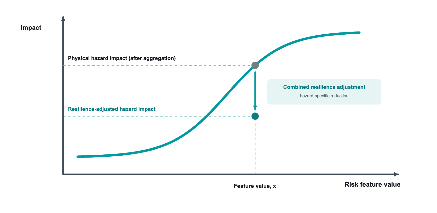
Feature impacts are aggregated by hazard before the combined-resilience adjustment is applied.
Examples of local adaptation measures include:
- flood barriers and drainage capacity reducing flood damage
- stronger building materials reducing wind damage
- local water storage and control reducing drought and flood impacts
This process is applied across all hazard categories in the CRRI.
2. Societal resilience adjustment
Climate resilience is not only physical. It also reflects the strength of local institutions, services, and communities.
Societal resilience is combined with local adaptation capacity rather than applied as a separate sequential offset. Locations with stronger societal resilience indicators are better positioned to absorb shocks and recover faster. Three indicators compose this input:
- Human Development Index (Global Data Lab) — subnational health, education, and income conditions.
- Gross fixed capital formation as a share of GDP (World Bank) — capacity to invest in and maintain physical infrastructure.
- Vulnerable population share (WorldPop) — the proportion of the local population in age groups least able to absorb a shock.
3. Asset-level remediation offset
This step applies when client-provided data is available through the Remediation Checklist.
The Remediation Checklist captures the mitigation measures in place at the asset or building level. When the checklist is filled, even partially, an additional asset-level remediation reduction is applied after the combined-resilience adjustment.
If no asset-level data is available via the Remediation Checklist, this asset-level adjustment is not applied. In that case, the Resilience-adjusted Risk Impact reflects local adaptation capacity and societal resilience only.
For more detail on how asset-level adaptation is quantified and applied, see Remediation Checklist: Quantifying Asset-level Adaptation.
.png)
Extract of the Remediation Checklist
Outputs: Physical and Resilience-Adjusted Risk
This framework produces two sets of results.
Physical Risk Impact
This is the baseline view, reflecting expected impact from hazard intensity alone.
Resilience-Adjusted Risk Impact
This view reflects the likely climate hazard impact after accounting for local adaptation capacity, societal resilience, and asset-level remediations.
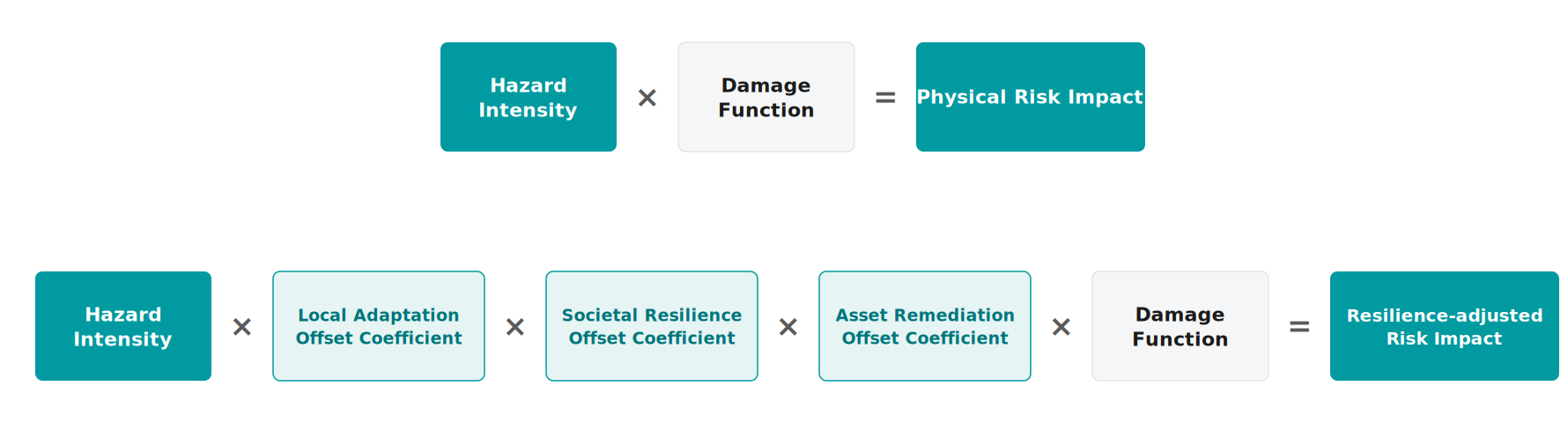
For each hazard, CRRI constructs Physical Risk Impact from feature-level damage curves, combines local adaptation and societal resilience into a normalized resilience value, and applies a hazard-specific impact reduction. Asset-level remediation is an additional optional reduction when checklist data is provided.
Together, these outputs help users distinguish between where hazards are most threatening and where adaptation is sufficient to offset them.
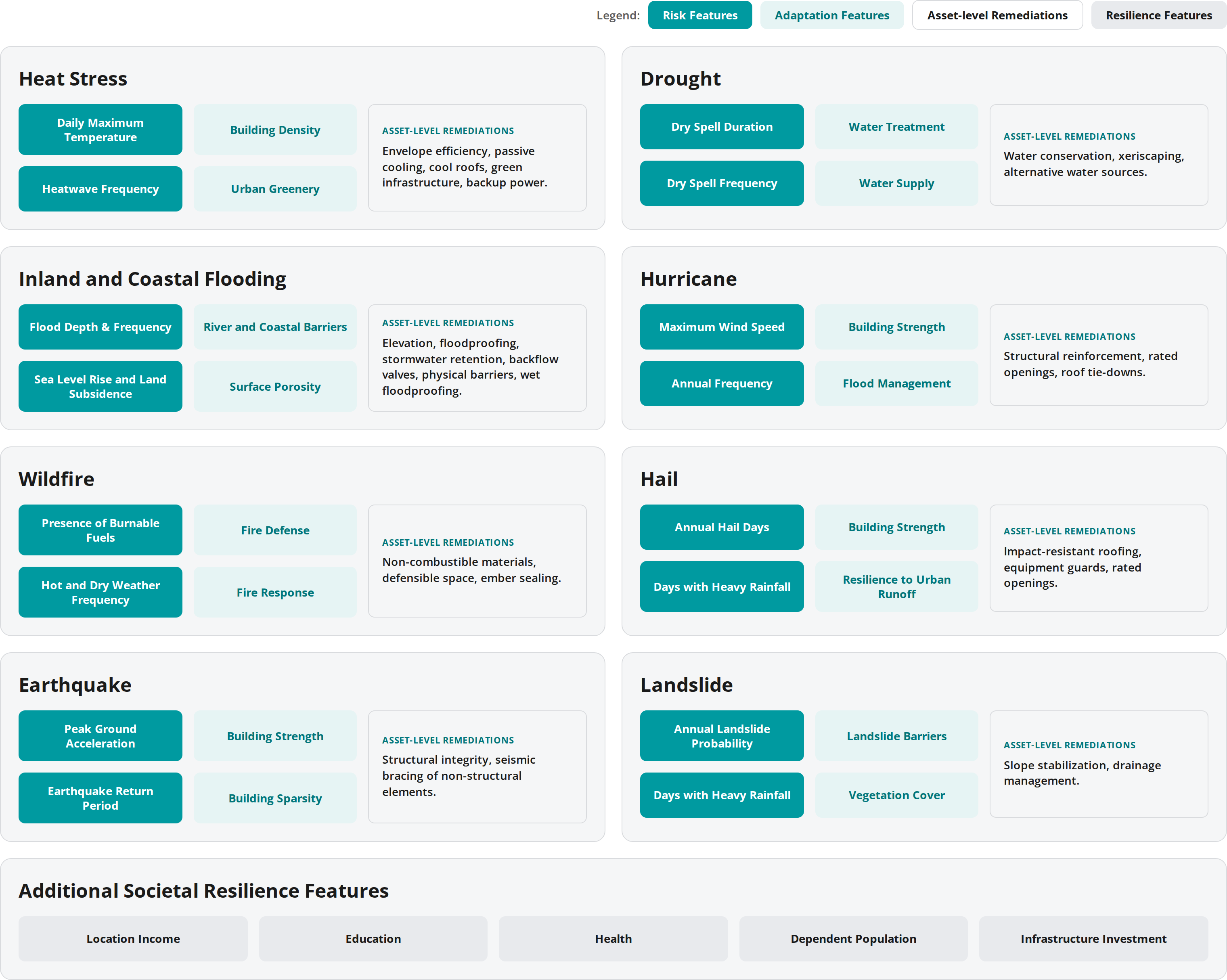
The Climate Risk and Resilience Index's feature matrix. Risk, adaptation, and resilience features are provided by AlphaGeo, while asset-level remediations are an optional, user-reported input.
The underlying adaptation and resilience inputs continue to expand as more data becomes available. This improves coverage, granularity, and the explanatory power of the framework over time.